We left the Wilsons Promontory Lightstation with one last look out to sea, admiring the chain of islands leading like stepping stones across the Strait. They’re the remnants of a landbridge between the Prom and Tasmania’s Freycinet, a link easily seen in the areas’ shared beauty: fine white sand, rough granite and bright orange lichen contrasting with a startlingly blue sea. It’s the nature, the beauty and the walking that brought us here, as well as a sense of unfinished business.
My husband and I had been coming to Wilsons Prom for decades, for day walks and multi-day hikes. But we’d never made it to the lighthouse, or stayed in the cottages converted to walkers’ accommodation. To tackle the trip, we booked two bunkrooms and roped in the Schultz family. It would be the first time either of our families – four adults and five kids aged nine to 15 – had attempted a four-day walk, but there was a reward waiting at the end. After 30km of trekking around the Prom, on the last night we’d have luxuries: the cottages’ hot showers and comfy beds.
Time has brought minimal obvious changes to the 50,000-hectare national park. The past is everywhere: in the bush, geology and Indigenous history. The area sits atop a granite batholith, a huge mass of cooled magma that forms the Prom’s boulders and mountains, as well as the nearby islands.
The Bunurong and Gunaikurnai people have lived in the area for thousands of years, maintaining strong connections to the place they call “Wamoon” or “Yiruk”. Wilsons Promontory appears in many dreamtime stories, with shellfish middens dotting its western coast.
Names such as Sealers Cove hint at the area’s colonial history, as do mining and cattle-grazing relics, while the lightstation has safeguarded ships for more than 150 years. The buildings of Tidal River betray the settlement’s origins as a commando training centre in the second world war.
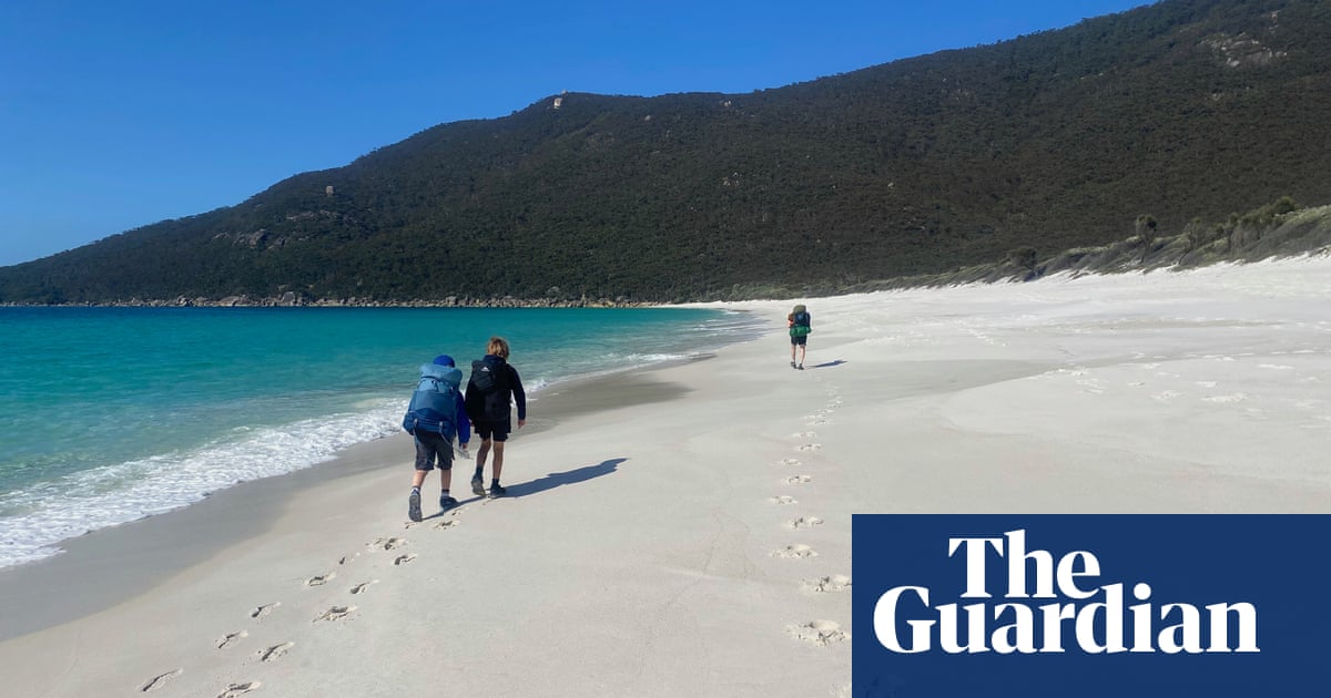
Our walk starts and ends at Tidal River, which is now the park’s main hub, with a shop, campsite and tourist information.
The first day was short, an 8km walk to our campsite at Oberon Bay – perfect for adjusting to packs. Under low clouds and strong headwinds, we walked through the tall tangle of tea-tree to Norman Beach where surfers shared the water with a darting seal. On the horizon the Glennie islands showed the boundary of Victoria’s largest marine national park.
A smattering of walkers followed the track to Little Oberon Beach, where they formed drifts of people sheltering from the wind. We followed the coast round to Norman Point lookout, which had views to our white sand destination. We picked our way across Growler Creek, admiring tangled piles of driftwood and boulders painted in orange lichen.
The campsites at the wide beach’s southern end are in tunnels of tea-tree, perfect for hide and seek. We set up tents while the kids played, until the sight of a dozy tiger snake made us pause the game. We switched to cards and took freezing swims and examined shells and massive cuttlefish bones, until a red sun set over the ocean.
Floods in 2021 destroyed some of the track to Sealers Cove, so we couldn’t walk the classic four-day circuit. This route is scheduled to reopen sometime in 2025. Instead, our second day’s route cut across the Prom from west to east, over dry heathland and tea-tree swamps, past looming boulders, to hit Waterloo Bay’s squeaky white sand and clear sea just after lunch.
after newsletter promotion
We continued on to the gorgeous Little Waterloo Bay, tucking our tents under trees minutes from the water. Wombats wandered through the short grass while superb fairy wrens darted about, their blue heads a similar shade to the nearby ocean. We spent the afternoon swimming again in the freezing sea, exploring the beach and the surrounding rock shelves.
The next day I woke to the sound of waves and the thought of hot showers. On this leg, the track climbed steeply through tea-tree and eucalypt forest dotted with wildflowers. Glimpses over the previous day’s route looked like scenes from the Whitsundays, only colder and further south. As we climbed we saw the lightstation ahead, a point decorated with tiny white buildings. After ups and downs and a thigh-burning final climb, we reached its lush lawn, kept trim by marsupials and divided by drystone walls, crowned by the granite lighthouse.
We were met by ranger Bailey, who showed us our home for the night, a historic lightstation keeper’s house with four bedrooms, a snug lounge, central kitchen with a long table; and the veranda with uninterrupted sea views. Then we raced for the showers.
Later, Bailey took us up the tower and explained its history. Built in 1859, the light originally burned oil. Its running was overseen by a team of four, their families forming a remote community. In a museum at the lightstation’s base, illustrations clipped from newspapers showed terrified women being hoisted ashore and a handwritten story told of the year supply ships ran late and Christmas dinner was delivered by a nine-year-old jumping on a Cape Barron goose.
Now the lighthouse is automated, with LED lights and self-changing bulbs. Ranger Bailey told us the fog can get so thick, buildings become invisible at five metres. But that day was clear. From the balcony we were treated to a sea of “whale soup” as humpbacks leapt and cavorted on their way down south.
Afterwards, we lay on the grass, watching wombats, wallabies and whales, until the sun disappeared behind South Point, the southern-most point of mainland Australia.
Our final day was the longest – 20-odd kilometres down the middle of the Prom. The sun baked and our sore bits ached, but two things kept spirits high: a generous supply of lolly snakes and the promise of ice-creams when we reached Tidal River. As we sat out the front of the Tidal River shop, we made a toast: to a great family adventure, and many more to come.
Food and accommodation
Walkers need to be entirely self-sufficient. Bookings are needed for all campsites and lighthouse accommodation. The Parks Victoria site gives further information, including about track closures and water availability.
Transport and logistics
The walk starts and finishes at Tidal River, and you’ll need your own transport to get there. Cars can be left in the walkers’ car park.