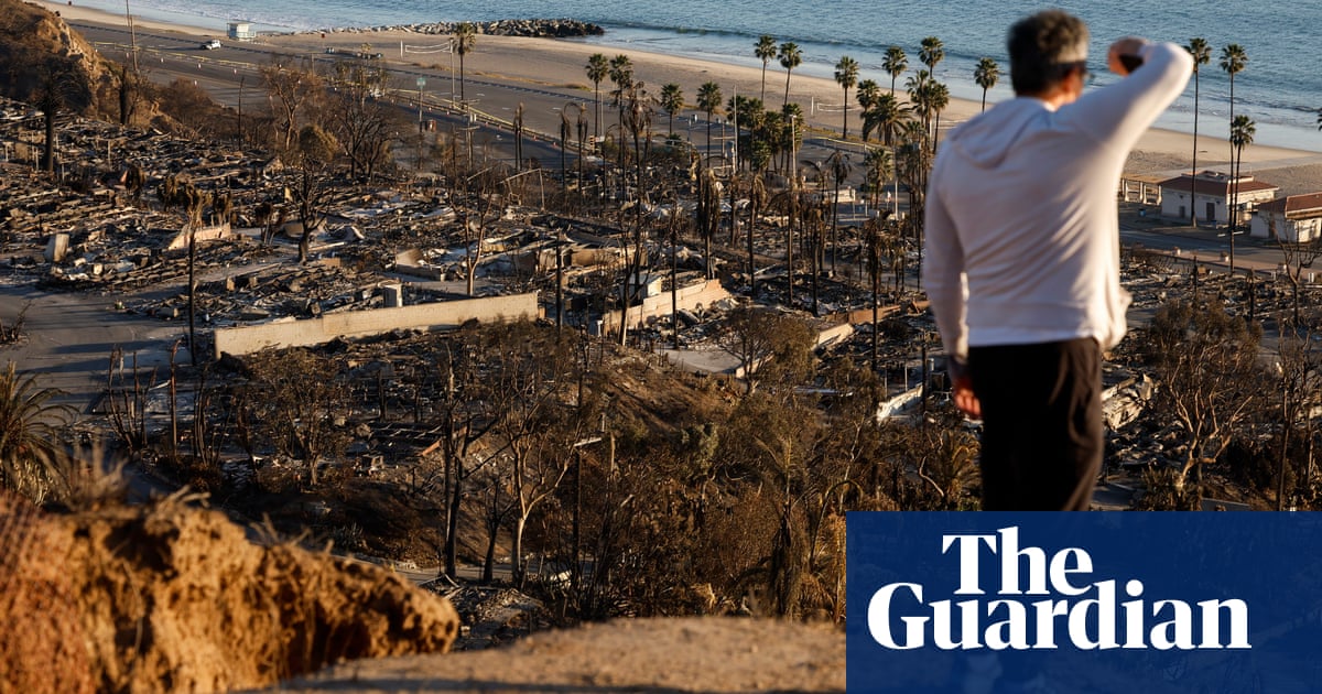
As the battle against the deadly fires in Los Angeles county enters its 10th day, officials are warning evacuees against returning to their homes due to the presence of toxic, hazardous waste and exposed power and gas lines.
During a Thursday press conference, Yonah Halpern, principal engineer with LA county public works said that toxins such as asbestos, and mercury can be found in fire debris and that the US Environmental Protection Agency and county fire department will be going house-to-house to assess and remove hazardous materials at no cost to the property’s owner.
The extreme winds behind the disastrous fires in Los Angeles are forecast to calm the rest of the week into the weekend, making it easier for firefighters to further efforts to put out the massive Palisades and Eaton fires that have been ablaze for over a week.
The National Weather Service said on Thursday that the “nine-day wind siege has finally ended” and the weekend will bring a “significant cooling trend” with higher humidity in the region. But it warned that high winds could pick up again early next week.
A marine layer is forecasted to come into the area on Thursday and Friday bringing with it desperately needed humidity, said James White, the incident meteorologist for the Eaton fire, during a Thursday press conference.
As of Thursday morning, crews were still working to fully contain the two largest fires in Los Angeles. The Palisades fire is 22% contained after burning more than 23,700 acres while the Eaton fire is 55% contained after burning roughly 14,100 acres.
The containment numbers are expected to rise rapidly in the coming days. The flames are no longer raging but scores of firefighters must scour every inch of the expansive fire footprints to ensure spot fires are extinguished and lines hold.
Even after forecasts warned of a “particularly dangerous situation” wind event on Wednesday, firefighters have been able to keep the fires within their footprints over the last few days.
Both fires have proved to be deadly and destructive. Officials said at least 27 people have died from the fires, while a total of 12,000 structures have been destroyed. The tragic toll is expected to climb. Natural disasters of this scale can indirectly cause deaths for decades to come.
While officials are still combing through the wreckage to tally and assess the destruction left in the wake of these fires, estimates put the total cost of the fire’s damage at around $250bn, making it the costliest fire in US history.
Quick Guide
US wildfire terms, explained
Show
Acres burned
US wildfires are measured in terms of acres. While the size of a wildfire doesn’t necessarily correlate to its destructive impact, acreage provides a way to understand a fire’s footprint and how quickly it has grown.
There are 2.47 acres in a hectare, and 640 acres in a square mile, but this can be hard to visualise. Here are some easy comparisons: one acre equates to roughly the size of an American football field. London’s Heathrow airport is about 3,000 acres. Manhattan covers roughly 14,600 acres, while Chicago is roughly 150,000 acres, and Los Angeles is roughly 320,000 acres.
Megafire
A megafire is defined by the National Interagency Fire Center as a wildfire that has burned more than 100,000 acres (40,000 hectares).
Containment level
A wildfire’s containment level indicates how much progress firefighters have made in controlling the fire. Containment is achieved by creating perimeters the fire can’t move across. This is done through methods such as putting fire retardants on the ground, digging trenches, or removing brush and other flammable fuels.
Containment is measured in terms of the percentage of the fire that has been surrounded by these control lines. A wildfire with a low containment level, such as 0% or 5%, is essentially burning out of control. A fire with a high level of containment, such as 90%, isn’t necessarily extinguished but rather has a large protective perimeter and a rate of growth that is under control.
Evacuation orders and warnings
Evacuation warnings and orders are issued by officials when a wildfire is causing imminent danger to people’s life and property. According to the California office of emergency services, an evacuation warning means that it’s a good idea to leave an area or get ready to leave soon. An evacuation order means that you should leave the area immediately.
Red flag warning
A red flag warning is a type of forecast issued by the National Weather Service that indicates when weather conditions are likely to spark or spread wildfires. These conditions typically include dryness, low humidity, high winds and heat.
Prescribed burn
A prescribed burn, or a controlled burn, is a fire that is intentionally set under carefully managed conditions in order to improve the health of a landscape. Prescribed burns are carried out by trained experts such as members of the US Forest Service and Indigenous fire practitioners. Prescribed burns help remove flammable vegetation and reduce the risk of larger, more catastrophic blazes, among other benefits.
Prescribed burning was once a common tool among Native American tribes who used “good fire” to improve the land, but was limited for much of the last century by a US government approach based on fire suppression. In recent years, US land managers have returned to embracing the benefits of prescribed burns, and now conduct thousands across the country every year.
More than 80,000 people remain under mandatory evacuation orders, with many anxious to get back to their homes. But officials said it would take time to conduct inspections and remove hazardous debris from neighborhoods.
In the aftermath of the firestorms that ravaged communities on all sides of Los Angeles, splintered power poles draped electric wires across roads, and toxic chemicals were released from crumpled homes. Even if the flames are extinguished, many dangers remain within burn scars that can put returning residents at risk.
Search and rescue efforts are also still under way, slowing the process of repairing utility infrastructure needed before the repopulation process can proceed, according to Cal Fire.
As of Thursday morning, inspections of both fire footprint were just over only halfway done, with no timeline given to residents and to when they will be completed. Cal Fire has released interactive maps of the Eaton fire and Palisades fire, detailing the status of each structure, which will be updated as the work is completed.
The LA fire department captain Erik Scott said the timeline of people returning home would vary as the damages need to be mapped and recorded.
“We want people to have realistic expectations,” he told the New York Times.
The last of the evacuation orders after the Camp fire in Paradise, California, in 2018 were lifted a month after the fire started, according to the Times. Residents of Lahaina, Maui, were allowed to return to their homes two months after a fire in 2023.
The California national guard has deployed troops to guard neighborhoods that have been evacuated, preventing residents from re-entering to check on their homes.
Karen Bass, the mayor of Los Angeles, met with displaced residents on Wednesday and said at a press conference that the city would try to ensure a quick rebuilding process for those who lost homes.
“People are ready to get started now,” she said. “If your property burned down and you want to rebuild it exactly as it was before, then you shouldn’t have to go through an elaborate, time-consuming permitting process.”


